
|
|
||
|
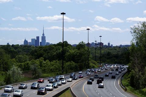
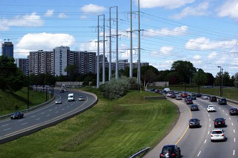
This 2009 photo shows the Don Valley Parkway looking south toward downtown Toronto. (Photo by Scott Steeves, www.asphaltplanet.ca.) |
||
|
Length: |
||
|
15.0 kilometers (9.3 miles) |
||
|
"People are saying, 'Save the Ravines!' This project is saving the ravines; it has made the Don Valley accessible to all the people. And it has cleared the place of the perverts." - Bill Weinstein, project manager for the Don Valley Parkway, as quoted in a 1961 Toronto Star interview |
||
|
THE DON VALLEY'S INDUSTRIAL PAST: The Don River Valley played an important role in the development of Toronto dating back to the 1790s, when the first water-powered sawmill was built at Tormorden Mills. Other industry followed in the first half of the nineteenth century, and by 1850s, a railroad line was built through the valley that still exists today. To improve waterborne shipping, as well as to make additional land available for railroads and industrial development, the City of Toronto straightened the Don River from Bloor Street south to Lake Ontario. The project, which cost $600,000, began in 1886, but was not completed until 1914. |
||

|
FROM "SPEEDWAY," TO "BOULEVARD," TO "TRAFFIC ARTERY:" In 1932, the City of Toronto introduced plans for a "Don Valley Speedway" to not only ease traffic congestion, but also provide employment for laborers left unemployed by the Great Depression. The Don Valley Speedway was to follow the route of the current Don Valley Parkway from the lakefront north to the area of Don Valley Brick Works Park, but instead of veering northeast, it would have veered northwest toward the intersection of Mount Pleasant Road and Davisville Avenue in the city's Davisville neighborhood. The city did not have the money to build the highway, and appeals for civic leaders to donate land for the highway went unanswered. In 1939, city transportation planner Norman Wilson, who later devised plans for Toronto's subway system, proposed a boulevard roughly along the same route as the "speedway," but plans were delayed by the onset of World War II. |
||
|
Postwar traffic demands led the City of Toronto to revive plans for the highway, now called the "Don Valley Traffic Artery." This need was anticipated in the city's 1943 master plan, though the route of the parkway veered west of the Don Valley at Tormorden Mills and continued north along Bayview Avenue, then veered back northeast at Lawrence Avenue toward the Toronto Bypass (today's Highway 401). The 1943 plan featured a spur from the parkway that was to begin near Eglington Avenue and continue northeast past Highway 401 toward Peterborough. It also included an interchange with a never-built, east-west expressway at Bloor Street. |
||
|
On January 1, 1946, Toronto voters approved construction of the highway by a nearly 3-to-1 margin. The city then borrowed $1.5 million to finance the highway's construction, and in 1949, the city proposed two spurs from the highway: a western spur that would have followed Rosedale Valley Road and Dupont Street, and an eastern spur that would have continued northeast along O'Connor Drive. The western spur eventually become part of a larger Crosstown Expressway proposal (via St. Clair Avenue), while the eastern spur immediately faced opposition from East York Township. Both spurs were never built. |
||
|
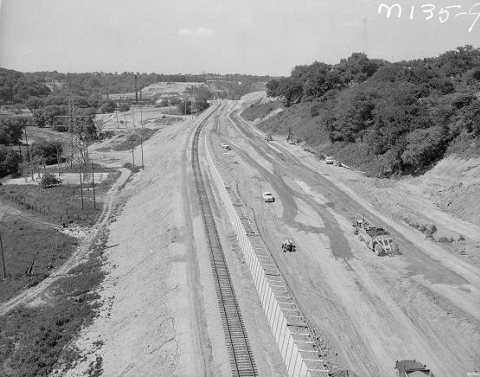
This 1959 photo shows the Don Valley Parkway under construction looking north toward EXIT 3 (Bayview Avenue / Bloor Street), also known as the Chester Hill interchange. The adjacent railroad had to be relocated to accommodate construction. (Photo from City of Toronto Archives.) |
||
|
"We'll move the railway over a piece. We'll tear down the hill. We'll shift the river over a piece, then we can have the highway through there." - James Maher, Toronto and York Planning Board Chairman |
||
|
GARINDER CHAMPIONS THE PARKWAY: The influential Metropolitan Executive Committee, which effectively served as the predecessor to the Metro Toronto government, was chaired by Frederick G. Gardiner, a lawyer and businessman who was active in Ontario's Progressive Conservative party. After the Lakeshore (Gardiner) Expressway, which was seen as the top expressway priority for Metro, Gardiner saw the construction of the Don Valley Parkway as the next highest priority. |
||
|
The Toronto and York Planning Board approved the route of the parkway in late 1953, just prior to the formation of the Metro government in 1954. At that time, the cost of the parkway was estimated at C$29 million. Bill Weinstein, who oversaw numerous highway projects in the Northeast states, including the Merritt Parkway, New Jersey Turnpike, and New York State Thruway, was hired as the project manager for the Don Valley Parkway. |
||
|
EXTENDING NORTH OF HIGHWAY 401: The final section of the Don Valley Parkway was a 1.4-kilometer (0.9-mile)-long section from Highway 401 north to EXIT 18 (Sheppard Avenue), which opened in the spring of 1967. The section was built on land purchased by Metro in the 1950s, continuing north on the former Woodbine Avenue alignment. The final cost of the Don Valley Parkway was C$47 million. Metro had purchased land as far north as Steeles Avenue for a future extension of the Don Valley Parkway; north of Steeles Avenue, the parkway extension was to be known as "New King's Highway." In the early 1970s, the Ministry of Transportation and Communications (MTC), the forerunner of today's Ministry of Transportation of Ontario (MTO) took over jurisdiction of the Don Valley Parkway north of Highway 401. It formed the initial section of Highway 404. |
||
|
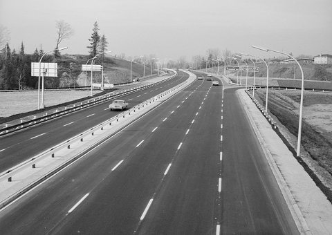
This 1966 photo shows the Don Valley Parkway looking north at EXIT 12 (Lawrence Avenue). Note that the northbound pull-through sign reads "To Woodbine Avenue." Woodbine Avenue formed the alignment for part of the Don Valley Parkway. (Photo from City of Toronto Archives.) |
||
|
A CALL FOR IMPROVED SAFETY: Even as the northerly stretches of parkway had yet to be completed in 1965, Metro Toronto Chief Coroner Morton Shulman released a report highlighting safety deficiencies on the parkway, including inadequate guardrails, exposed slopes that could be vulnerable to erosion, and lightpoles that did not meet modern safety standards. One step toward a safer parkway was taken in 1966 when emergency telephone call boxes were installed along the length of the parkway. After a 1969 rainstorm that led to the erosion of a slope near Don Mills Road that left the parkway in mud as much as 90 centimeters (three feet) deep, slopes were covered in sod and stakes to help prevent future erosion. |
||
|
In 1994, the city's Road Emergency Services Communications Unit (RESCU) began operations on the Gardiner Expressway to monitor traffic and respond to incidents. The emergency call boxes were removed, and in their place the city installed traffic cameras, road sensors, and variable message signs (VMS) along the expressway. Around this time, concrete median barriers replaced steel guardrails, and by the end of 1990s, high-mast light towers replaced the low-pressure sodium lights on davit poles. |
||
|
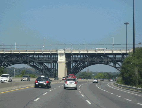
This 2013 photo shows the Don Valley Parkway looking north toward the Bloor Street Viaduct. (Prince Edward Viaduct). Built between 1913 and 1918, the Bloor Street Viaduct carries five vehicular lanes on its upper deck and two subway tracks on its lower deck over the Don River and the Don Valley Parkway. (Photo by Steve Anderson.) |
||

|
GET ON THE BUS: In 2007, GO Transit (now part of the Metrolinx transit agency) proposed a $12 million plan to allow buses to use the center median of the parkway. Although the plan, which required soil testing and an environmental assessment, did not appear in 2008 provincial mass transit plans, the Toronto City Council ultimately approved a plan to allow buses to use the center median from the Highway 401-404 interchange south to Eglinton Avenue in 2010. The first buses began using the lane in September of that year, and the buses are permitted to use the lane when other traffic is moving at a speed of 60 km/h (37 MPH) or less, provided that the buses travel no faster than 20 km/h (12 MPH) above the speed of the prevailing traffic. Buses using the Don Valley Parkway bus lanes can continue north onto the Highway 404 HOV lanes, though there is no direct connection to those lanes, nor can passenger cars traveling in the Highway 404 HOV lanes continue south onto the Don Valley Parkway bus lanes. |
||

|
NEW EXIT NUMBERS EXTEND 404 SCHEME, THOUGH WITH A TWIST: In 2017, the City signed new exit numbers along the length of the Don Valley Parkway, with the new exit numbers reflecting the distance in kilometers from the south end of the parkway at the Gardiner Expressway junction. Although the exit numbers theoretically are a continuation of the kilometer-based exit numbering scheme on Highway 404, there actually is a two-kilometer difference, such that EXIT 17 on southbound Highway 404 is the interchange for Highway 401, while the unsigned EXIT 15 on the northbound Don Valley Parkway also is for Highway 401. |
||
|
COMING SOON… A NEW CONNECTION TO THE GARDINER: In 2008, Waterfront Toronto, a private organization promoting redevelopment of the Toronto lakefront, proposed the demolition of the elevated Gardiner Expressway east of Jarvis Street. A rebuilt and widened Lake Shore Boulevard would accommodate the traffic flows from the Gardiner Expressway, similar to what was done for the "Gardiner East" segment that was removed in 2001, and in the absence of the elevated Gardiner, ramps connecting to Lake Shore Boulevard would provide the only access to the Don Valley Parkway. The C$300 million plan had the support of Mayor David Miller, and the Toronto City Council prompted the provincial government to proceed with an environmental assessment. Following the election of Rob Ford as Mayor, who favored keeping the elevated Gardiner, the removal project was shelved. |
||
|
This 2009 photo shows the Don Valley Parkway looking north from the Spanbridge Road overpass. Ahead is the Ontario Hydro right-of-way, which has been the subject for potential use for a Scarborough Expressway over the years. (Photo by Scott Steeves, www.asphaltplanet.ca.) |
||

|
SOURCES: "Gardiner Wants New Ball Park, Cost $5,000,000," Toronto Star (10/06/1954); "Gardiner Asks Don Parkway, Others Subway," Toronto Star (3/21/1956); "Planning Board Seeks $60,000,000 To Extend Three Expressways," Toronto Star (4/18/1957); "Spend $190,000,000 on Subway in 10 Years, Gardiner Plan" by Lee Belland, Toronto Star (2/04/1958); "The Don Valley Parkway--Makes Driving a Pleasure" by Ron Haggart, Toronto Star (4/14/1961); "New Parkway Has the Same Old Hazards, Say Shulman," Toronto Star (11/21/1966); "Mudslide Closes Northbound Don Parkway," Toronto Star (4/19/1969); "Metro Okays Most Roadwork in 20 Years," Toronto Star (6/22/1989); "DVP Section Cut to Two Lanes Until Autumn," Toronto Star (6/18/1994); "New Toll Lanes Touted for DVP" by Paul Moloney and Joseph Hall, Toronto Star (3/12/2001); "That Time When the Don River Was Straightened" by Chris Bateman, BlogTO.Com (4/14/2012); "The Don Valley Parkway: How Toronto Keeps It in A1 Shape" by Mark Berkovitz, City of Toronto (2012); "That Time Toronto Opened the Don Valley Parkway" by Chris Bateman, BlogTO.Com (8/10/2013); New Implementation Approach for the F.G. Gardiner Expressway: Revised Strategic Rehabilitation Plan, City of Toronto (2016); Missing Links: A History of Toronto's Controversial Unfinished Expressway System by James B. Alcock (2017); "Should the Eastern Gardiner Be Torn Down? No" by Murtaza Haider and Andy Manahan, Toronto Star (10/09/2018); "Gardiner Expressway Rehabilitation Strategy," City of Toronto "Don Valley Parkway Bridge Repairs Will Reduce Lanes for Months, Toronto Star (6/26/2019); James Alcock; Scott Steeves. |
||
|
DON VALLEY PARKWAY LINKS: |
||
|
DON VALLEY PARKWAY CURRENT TRAFFIC CONDITIONS: |
||
|
DON VALLEY PARKWAY VIDEO LINKS: |
||
|
THE EXITS OF GREATER TORONTO: |
||
|
Back to The Roads of Greater Toronto home page. |
||
|
Site contents © by Eastern Roads. This is not an official site run by a government agency. Recommendations provided on this site are strictly those of the author and contributors, not of any government or corporate entity. |
||